
Thermal Drone Inspection
Infrared Imaging Delivering Advanced Insights
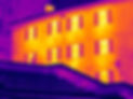
Get data for inspection purposes in commercial and residential applications and find potential problem areas before they become disasters.
AGL Drone Surveys helps you locate inefficiencies or faults in solar grids to quickly identify and address operational issues. An ITC Certified thermographer ensures in focus and viable imaging, adjusts for emissivity levels, and can interpret results if desired.
Using Drone Surveys To Avoid Costly Operational Issues
Infrared imaging delivers on the promise of advanced insights. Recognition and identification of thermal anomalies provide real-time visuals to support live subjects in the public safety space from a distance. Drone photography, image capture and interpretation for inspection purposes is guided by accepted industry standards, with capture at nadir to the target surfaces to ensure proper reflectivity and accurate readings.
A 640x512 resolution thermal camera with a 61 degree DFOV provides a solid platform for capturing thermal transfer data at a safe distance.
AGL provides comprehensive Drone Survey services in the Puerto Rico and USVIs.